


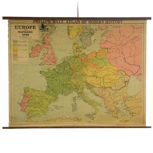


Vintage school map - Europe under Napoleon
SOLD
Although this item has been sold, we have a range of similar items that may be of interest to you.
View similar items
Delivery Quote Request
Please fill in the form below to request a delivery quote from Leslie and Baggott.
Contact Leslie and Baggott
 Castle Douglas, United Kingdom
Simply fill in the below form to get in touch with Leslie and Baggott regarding this item.
About this item
Vintage school map
Philips Wall Atlas of Modern History, Europe Under Napoleon 1810, showing countries under Napoleon's rule, his allies and independent nations
mounted on canvas with oak poles
published by George Philip & Son, 1953
Condition: good bright colours to the countries, the edges are slightly frayed, ink stain to the sea north of Scotland.
93cm H, 122cm W (the poles).
Additional Information
B14184 (AB-71665)
W: 122cm (48")H: 93cm (36.6")
Vintage (1970 onwards), Unknown
![]() Castle Douglas, United Kingdom
Castle Douglas, United Kingdom
Leslie & Baggott’s ethos is to source stock items fresh from private houses across Scotland and beyond, some offered ‘as found’ while others are put into fine showroom condition. The main customer target being both the private customer, interior decorator and fellow antique dealer both at...

 Gall & Inglis Edinburgh")


